
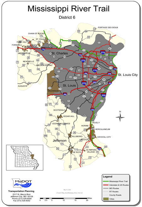
Mississippi River Trail
The Mississippi River Trail (MRT) is a designated bicycle and pedestrian trail that traverses the shores of the Mississippi River in the United States.
The trail goes from the headwaters at Lake Itasca in Minnesota to near the mouth of the river in Venice, LA. Much of the trail follows roadways used by motor vehicles although some of the route is on multi-use trails.
Herculaneum is located on the MRT and features two viewing areas of the river.
DIRECTIONS:
SOUTH FROM THE ST. LOUIS CITY/COUNTY LINE TO HERCULANEUM:
Continue south on Highway 231 (Telegraph Road) for approximately 1.3 miles; Highway 231 becomes Kingston in the vicinity of Jefferson Barracks County Park; continue on Highway 231/Kingston for approximately 2.0 miles;
Kingston becomes Telegraph Road/Highway 231; continue on Telegraph Road/Highway 231 for approximately 8 miles to the Jefferson County line (approximate 11 miles)
Continue SW on Highway 231 for approximate 2.2 miles to the junction of State Highways 61-67.
Turn left onto Highway 61-67 (Jeffco Boulevard) and continue south for approximately 10.2 miles to Herculaneum (Highway 61-67 becomes Commercial Boulevard in Pevely and Herculaneum)
Turn left on Joachim Avenue for approximately 0.2 miles; turn left on North Main Street and continue approximately 0.2 miles to Dunklin Drive; turn left and continue for approximately 0.4 miles to the Governor Daniel Dunklin Grave Site that overlooks the Mississippi River.
A second viewing area can be reached by continuing past Dunklin Drive on North Main Street for approximately 0.4 miles to the Dunklin-Fletcher Park on the left side.
NORTH FROM THE STE. GENEVIEVE COUNTY LINE TO HERCULANEUM:
Continue north from the Ste. Genevieve County Line on Highway 61 to the intersection with Highway 61-67 (approximately 10.4 miles);
Turn right on Highway 61-67 and continue approximately 5.5 miles to North Joachim Avenue; turn right on North Joachim Avenue for approximately 0.2 miles; turn left on North Main Street and continue approximately 0.2 miles to Dunklin Drive; turn left and continue for approximately 0.4 miles to the Governor Daniel Dunklin Grave Site that overlooks the Mississippi River.
A second viewing area can be reached by continuing past Dunklin Drive on North Main Street for approximately 0.4 miles to the Dunklin-Fletcher Park on the left side.
Dunklin's Grave Site is one of the 88 state parks and historical sites that are included in the Centennial Passport program.